


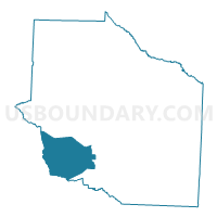
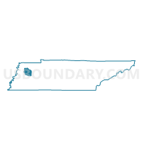
08-14 Brazil Fire Station Voting District, Gibson County, Tennessee
About
Outline

Summary
| Unique Area Identifier | 668510 |
| Name | 08-14 Brazil Fire Station Voting District |
| County | Gibson County |
| State | Tennessee |
| Area (square miles) | 38.55 |
| Land Area (square miles) | 38.55 |
| Water Area (square miles) | 0.00 |
| % of Land Area | 100.00 |
| % of Water Area | 0.00 |
| Latitude of the Internal Point | 35.90274610 |
| Longtitude of the Internal Point | -89.06570260 |
Maps

Graphs
Select a template below for downloading or customizing gragh for 08-14 Brazil Fire Station Voting District, Gibson County, Tennessee


Neighbors
Neighoring Voting District (by Name) Neighboring Voting District on the Map
- 08-12 Edison Comm Center Voting District, Gibson County, TN
- 08-15 Spring Hill Voting District, Gibson County, TN
- 09-20 Court House Voting District, Gibson County, TN
- 1 Voting District, Crockett County, TN
- 4 Voting District, Crockett County, TN
- 6 Voting District, Crockett County, TN
Top 10 Neighboring County Subdivision (by Population) Neighboring County Subdivision on the Map
- District 9, Gibson County, TN (1,784)
- District 8, Gibson County, TN (1,637)
- District 4, Crockett County, TN (1,280)
- District 6, Crockett County, TN (1,240)
- District 1, Crockett County, TN (1,213)
Top 10 Neighboring Elementary School District (by Population) Neighboring Elementary School District on the Map
Top 10 Neighboring Secondary School District (by Population) Neighboring Secondary School District on the Map
Top 10 Neighboring Unified School District (by Population) Neighboring Unified School District on the Map
- Gibson County School District, TN (18,363)
- Trenton Special School District, TN (8,670)
- Crockett County School District, TN (6,650)
Top 10 Neighboring State Legislative District Lower Chamber (by Population) Neighboring State Legislative District Lower Chamber on the Map
Top 10 Neighboring State Legislative District Upper Chamber (by Population) Neighboring State Legislative District Upper Chamber on the Map
Top 10 Neighboring 111th Congressional District (by Population) Neighboring 111th Congressional District on the Map
Top 10 Neighboring Census Tract (by Population) Neighboring Census Tract on the Map
- Census Tract 9667, Gibson County, TN (5,925)
- Census Tract 9611, Crockett County, TN (4,247)
- Census Tract 9612, Crockett County, TN (1,895)
- Census Tract 9668, Gibson County, TN (1,273)